Click here to download 5K map
5K Course
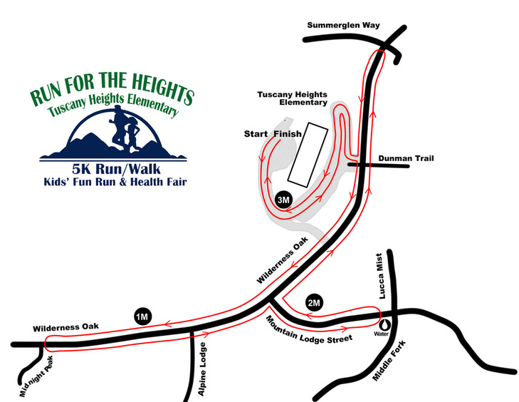
The 3.1 mile hilly course begins and ends in the back of Tuscany Heights Elementary. Participants will run/walk:
- Down and veer left across front of school driveway out to Wilderness Oak
- South on Wilderness Oak to the end and turnaround
- North on Wilderness Oak to Mountain Lodge Street
- East on Mountain Lodge and turnaround at Lucca Mist
- West on Mountain Lodge back to Wilderness Oak
- North on Wilderness Oak to turnaround at Summerglen Way
- South on Wilderness Oak to school driveway
- Right at school driveway (at Dunman Trail) and proceed right to complete driveway loop, past the front of school, and back to the finish line.
Fun/Run Course
The kids' start/finish line is located in the back parking lot of Tuscany Heights Elementary School. Kids will run from the back of
school and turn left onto the driveway in front of the school. The run will proceed across the front of the school and then down and around the circle driveway (past the entrance at Dunman Trail.) Once the driveway loop is complete, the kids will run back to the start/finish line. Course is approximately ¾ of a mile.
This website is created and managed by PTA volunteers.
Please email feedback, questions, or concerns regarding this website to the Run for the Heights committee.
Please email feedback, questions, or concerns regarding this website to the Run for the Heights committee.